- Joined
- Sep 18, 2023
- Messages
- 4,273
- Reaction score
- 25
- Points
- 48
- Location
- Canada
- Website
- oneddl.org
- NullCash
- 117,362
Free Download Aquaveo Groundwater Modeling System (GMS) 10.9.2 | 1.9 Gb
Aquaveo, a water resources consulting company, is pleased to announce availabilityGroundwater Modeling System (GMS) 10.9.2is the most advanced software system available for performing groundwater simulations in a three-dimensional environment
Owner:Aquaveo
Product Name:Groundwater Modeling System (GMS)
Version:10.9.2
Supported Architectures:x64
Website Home Page :www.aquaveo.com
Languages Supported:english
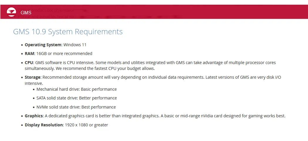
System Requirements:Windows *
Size:1.9 Gb.
The Groundwater Modeling System (GMS) has made a slight change in version 10.9 to how we model MODFLOW 6 to make modeling more efficient for you. Now, in GMS 10.9, the Map from Coverage command has moved directly into the package dialog. This means no more jumping back and forth between windows; you can map your data right where you're working.
What's New in GMS 10.9.2 - Date: January 09, 2026
Display
- 15935 Label Discrepancy for Coverages.
- 15443 Typing escape key in Display Options dialog makes GUI disappear.
- 15470 Changing the Color Ramp for Vector Display Doesn't Actually Change Anything.
MODFLOW
- 15937 Visual for "Specified (IRCHCONC)" Checkbox is Inconsistent.
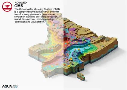
TheGroundwater Modeling System (GMS)is a comprehensive graphical user environment for performing groundwater simulations. The entire GMS system consists of a graphical user interface (the GMS program) and a number of analysis codes (MODFLOW, MT3DMS, etc.). GMS was designed as a comprehensive modeling environment. Several types of models are supported and facilities are provided to share information between different models and data types. Tools are provided for site characterization, model conceptualization, mesh and grid generation, geostatistics, and post-processing.
GMS
Instructional videos for the Groundwater Modeling System (GMS) program developed by Aquaveo.
Aquaveois a pioneer of GIS-based software solutions for hydraulic, hydrologic and groundwater modeling. Our products have been refined over two decades to create the most advanced environmental modeling and visualization software available. In addition to interfacing with industry standard numerical models, we develop custom desktop and cloud-based applications tailored to specific needs. Aquaveo began as a part of the Engineering Computer Graphics Laboratory at Brigham Young University in 1985. The lab was reorganized and the name was changed in September, 1998 to the Environmental Modeling Research Laboratory (EMRL). In April, 2007, the main software development team at EMRL entered private enterprise as Aquaveo, LLC.

Rapidgator
bgf30.Aquaveo-Groundwater-Modeling-System-GMS-10-9-2.rar.html
DDownload
bgf30.Aquaveo-Groundwater-Modeling-System-GMS-10-9-2.rar
FreeDL
bgf30.Aquaveo-Groundwater-Modeling-System-GMS-10-9-2.rar.html
Links are Interchangeable - No Password - Single Extraction